
File:Vue aérienne de Sétif (Algérie).jpg

Size of this preview: 800 × 600 pixels. Other resolutions: 320 × 240 pixels | 640 × 480 pixels | 1,024 × 768 pixels.
kuleha na ku anama hixitalo (1,024 × 768 ku anama na leha hi ti phikisele, Vukulu bya fayili: 617 KB, muxaka waMIME: image/jpeg)
.jpg)
Nkomiso
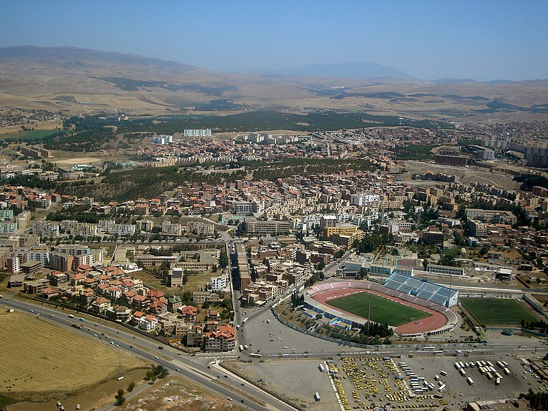
| Description | Vue aérienne sur la ville de Sétif (Algérie) |
| Date | |
| Source |
|
| Author | Adel Kamel from Ermont, France |
| Camera location | | View this and other nearby images on: OpenStreetMap |
|---|
.jpg¶ms=036.180562_N_0005.415573_E_globe:Earth_type:camera_source:Flickr_&language=ts)
Nawu wo pfumelela
This file is licensed under the Creative Commons Attribution 2.0 Generic license.
Attribution: Adel Kamel
- You are free:
- to share – to copy, distribute and transmit the work
- to remix – to adapt the work
- Under the following conditions:
- attribution – You must give appropriate credit, provide a link to the license, and indicate if changes were made. You may do so in any reasonable manner, but not in any way that suggests the licensor endorses you or your use.
| This image, originally posted to Flickr, was reviewed on August 11, 2011 by the administrator or reviewer File Upload Bot (Magnus Manske), who confirmed that it was available on Flickr under the stated license on that date. |
|
According to article 50 of the Algerian copyright law, it shall be lawful to reproduce or to communicate to the public, without authorization of the author and without remuneration, a work of architecture or the fine arts, a work of applied arts or a photographic work that is permanently situated in a public place, with the exception of art galleries, museums and classified cultural or natural sites.
See COM:CRT/Algeria#Freedom of panorama for more information.
|
Matimu ya fayili
thlava eka siku/nkarhi leswaku u vona leswi fayili ayirixiswona hi knarhi walowo
| Siku/Nkarhi | Xifanisonyana | Mpimo | Mutirhisi | Nhlamulo | |
|---|---|---|---|---|---|
| Sweswinyana | 10:45, 11 Mhawuri 2011 | | 1,024 × 768 (617 KB) | File Upload Bot (Magnus Manske) | {{Information |Description=La ville de Sétif comme je ne l'es jamais vue, ce fut une émotion particulier de voir la gare routière qui a pour moi une signification particulière |Source=[http://www.flickr.com/photos/adelkamel/5313772204/ Sétif] * Uploa |
Ntsengo wakutirhisiwa ka fiyili leyi
2 matluka lawa makhwekela eka fayili leyi:
Global file usage
The following other wikis use this file:
- Usage on af.wikipedia.org
- Usage on ar.wikipedia.org
- Usage on arz.wikipedia.org
- Usage on ast.wikipedia.org
- Usage on az.wikipedia.org
- Usage on bcl.wikipedia.org
- Usage on be.wikipedia.org
- Usage on bg.wikipedia.org
- Usage on br.wikipedia.org
- Usage on ca.wikipedia.org
- Usage on ceb.wikipedia.org
- Usage on cs.wikipedia.org
- Usage on da.wikipedia.org
- Usage on el.wikipedia.org
- Usage on el.wikivoyage.org
- Usage on en.wikipedia.org
- Usage on en.wikivoyage.org
- Usage on eo.wikipedia.org
- Usage on es.wikipedia.org
- Usage on eu.wikipedia.org
- Usage on fa.wikipedia.org
- Usage on fr.wikipedia.org
- Usage on fr.wikivoyage.org
- Usage on gl.wikipedia.org
- Usage on ha.wikipedia.org
- Usage on he.wikivoyage.org
- Usage on hy.wikipedia.org
- Usage on ia.wikipedia.org
- Usage on id.wikipedia.org
View more global usage of this file.
.jpg)
.jpg)