
File:Map of South Africa with Dr Kenneth Kaunda highlighted (2011).svg

Size of this PNG preview of this SVG file: 684 × 599 pixels. Other resolutions: 274 × 240 pixels | 548 × 480 pixels | 876 × 768 pixels | 1,168 × 1,024 pixels | 2,337 × 2,048 pixels | 809 × 709 pixels.
kuleha na ku anama hixitalo (Fayili ya SVG, vukulu lebyi ringaneke 809 × 709 hi ti phikisele, vukulu bya fayili: 488 KB)
.svg)
Nkomiso
| Description |
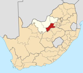
English: Map of district boundaries in South Africa, as they will be after the municipal elections of 18 May 2011, with the Dr Kenneth Kaunda District Municipality highlighted in red within the North West in yellow. |
| Date | |
| Source | Own work |
| Author | Htonl |
Nawu wo pfumelela
I, the copyright holder of this work, hereby publish it under the following licenses:

|
Permission is granted to copy, distribute and/or modify this document under the terms of the GNU Free Documentation License, Version 1.2 or any later version published by the Free Software Foundation; with no Invariant Sections, no Front-Cover Texts, and no Back-Cover Texts. A copy of the license is included in the section entitled GNU Free Documentation License. |
This file is licensed under the Creative Commons Attribution-Share Alike 4.0 International, 3.0 Unported, 2.5 Generic, 2.0 Generic and 1.0 Generic license.
- You are free:
- to share – to copy, distribute and transmit the work
- to remix – to adapt the work
- Under the following conditions:
- attribution – You must give appropriate credit, provide a link to the license, and indicate if changes were made. You may do so in any reasonable manner, but not in any way that suggests the licensor endorses you or your use.
- share alike – If you remix, transform, or build upon the material, you must distribute your contributions under the same or compatible license as the original.
You may select the license of your choice.
Matimu ya fayili
thlava eka siku/nkarhi leswaku u vona leswi fayili ayirixiswona hi knarhi walowo
| Siku/Nkarhi | Xifanisonyana | Mpimo | Mutirhisi | Nhlamulo | |
|---|---|---|---|---|---|
| Sweswinyana | 03:08, 14 Mudyaxihi 2011 | | 809 × 709 (488 KB) | Htonl | == Summary == {{Information |Description ={{en|1=Map of district boundaries in South Africa, as they will be after the municipal elections of 18 May 2011, with the [[w:Dr Kenneth Kaunda District Municipality |
Ntsengo wakutirhisiwa ka fiyili leyi
tluka leri rikhekela eka fayili leyi:
Global file usage
The following other wikis use this file:
- Usage on af.wikipedia.org
- Potchefstroom
- Stilfontein
- Klerksdorp
- Ventersdorp
- Orkney, Noordwes
- Wolmaransstad
- Makwassie
- Leeudoringstad
- Venterskroon
- Hartbeesfontein
- Kanana, Noordwes
- Sjabloonbespreking:Suid-Afrikaanse distriksmunisipaliteit navbox
- Boskop
- Vaal Reefs
- Dominionville
- Doringkruin
- Tigane
- Umzimhle
- Kgakala
- Boskuil
- Witpoort, Noordwes
- Trotsville
- Tswelelang
- Rulaganyang
- Tshing
- Makokskraal
- Vlieger
- Welgevonden
- Bruidegomskraal
- Appeldraai
- GaMogopa
- Doornkop, Noordwes
- Goedgevonden A
- Lindequesdrif
- Matlwang
- Usage on de.wikivoyage.org
- Usage on en.wikipedia.org
View more global usage of this file.
.svg)
.svg)