
File:LocationUganda.png
Xifaniso lexi axikuriseki kuhundza laha.
LocationUganda.png (250 × 115 ku anama na leha hi ti phikisele, Vukulu bya fayili: 7 KB, muxaka waMIME: image/png)
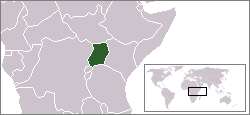
Location map for the Uganda.
Originally created for English Wikipedia by Vardion.
| |
This work has been released into the public domain by its author, Vardion, at the Xi Nghezi Wikipediya project. This applies worldwide. In case this is not legally possible: |

|
File:LocationUganda.svg is a vector version of this file. It should be used in place of this PNG file when not inferior.
File:LocationUganda.png → File:LocationUganda.svg
For more information, see Help:SVG. |
 |
Matimu ya fayili
thlava eka siku/nkarhi leswaku u vona leswi fayili ayirixiswona hi knarhi walowo
| Siku/Nkarhi | Xifanisonyana | Mpimo | Mutirhisi | Nhlamulo | |
|---|---|---|---|---|---|
| Sweswinyana | 22:42, 30 Mhawuri 2011 | | 250 × 115 (7 KB) | Hoshie | added South Sudan |
| 03:41, 13 N'wendzamhala 2004 |  | 250 × 115 (6 KB) | EugeneZelenko | Location map for the Uganda.<br/>Originally created for English Wikipedia by Vardion.<br/>{{PD}}<br/>Category:Country locator maps |
Ntsengo wakutirhisiwa ka fiyili leyi
tluka leri rikhekela eka fayili leyi:
Global file usage
The following other wikis use this file:
- Usage on ar.wikinews.org
- Usage on bg.wikipedia.org
- Usage on bpy.wikipedia.org
- Usage on br.wiktionary.org
- Usage on bs.wikipedia.org
- Usage on ceb.wikipedia.org
- Usage on de.wikinews.org
- Usage on de.wikivoyage.org
- Usage on de.wiktionary.org
- Usage on en.wikipedia.org
- Usage on en.wiktionary.org
- Usage on es.wikipedia.org
- Usage on frp.wikipedia.org
- Usage on fr.wikipedia.org
- Usage on he.wikipedia.org
- Usage on he.wikivoyage.org
- Usage on hif.wikipedia.org
- Usage on id.wikipedia.org
- Usage on ig.wikipedia.org
- Usage on incubator.wikimedia.org
- Usage on it.wikipedia.org
- Usage on it.wikivoyage.org
- Usage on ja.wikipedia.org
- Usage on ja.wikinews.org
- Usage on ja.wiktionary.org
- Usage on ko.wikipedia.org
- Usage on kw.wikipedia.org
- Usage on lij.wikipedia.org
- Usage on li.wikipedia.org
- Usage on lt.wikipedia.org
- Usage on lt.wiktionary.org
- Usage on mzn.wikipedia.org
- Usage on nds.wikipedia.org
- Usage on nds.wiktionary.org
- Usage on nl.wikipedia.org
- Usage on nl.wikivoyage.org
- Usage on nn.wikipedia.org
View more global usage of this file.