File:Geographic distribution of Bengali language.png

Page contents not supported in other languages.
Kusuka e Wikipedia

kuleha na ku anama hixitalo(2,806 × 2,080 ku anama na leha hi ti phikisele, Vukulu bya fayili: 1.36 MB, muxaka waMIME: image/png)

Fayili leyi yi suka e Wikimedia Commons naswona swinga endleka leswaku yi tirhisiwa hiti phurojeki tin'wanana. Nhlamuselo ya yona leyi nge ndzeni ka tluka ro hlamusela hi yona leyi kombiweke ehansi.

Nkomiso

Description
Ελληνικά: Γεωγραφική κατανομή της Βεγγαλικής Γλώσσας ανά επαρχία της Ινδίας και στο Μπανγκλαντές, τα χρώματα στις επαρχίες ποικίλουν ανάλογα με το ποσοστό ομιλητών (δεδομένα απογραφής 2011). Παράγωγο του αρχείου India district map (de-facto).svg.
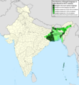
English: Geographic distribution of Bengali language in India and Bangladesh. The map covers each district of India and the five shades of green show the percentage of Bengali language speakers in each district. Source: Indian census 2011. Feel free to enrich the map with data for more Indian districts, or fix any mistakes. Derivative of the file India district map (de-facto).svg.
Date
Source Own work
Author NikosLikomitros

Nawu wo pfumelela

I, the copyright holder of this work, hereby publish it under the following license:
w:en:Creative Commons
attribution share alike
This file is licensed under the Creative Commons Attribution-Share Alike 4.0 International license.
You are free:
  • to share – to copy, distribute and transmit the work
  • to remix – to adapt the work
Under the following conditions:
  • attribution – You must give appropriate credit, provide a link to the license, and indicate if changes were made. You may do so in any reasonable manner, but not in any way that suggests the licensor endorses you or your use.
  • share alike – If you remix, transform, or build upon the material, you must distribute your contributions under the same or compatible license as the original.

Captions

Add a one-line explanation of what this file represents
Geographic distribution of Bengali language in India and Bangladesh. The map covers each district of India and the five shades of green show the percentage of Bengali language speakers in each district. Source: Indian census 2011.

Items portrayed in this file

depicts Xi Nghezi

copyright status Xi Nghezi

copyrighted Xi Nghezi

inception Xi Nghezi

26 Khotavuxika 2022

media type Xi Nghezi

image/png

Matimu ya fayili

thlava eka siku/nkarhi leswaku u vona leswi fayili ayirixiswona hi knarhi walowo

Siku/NkarhiXifanisonyanaMpimoMutirhisiNhlamulo
Sweswinyana15:05, 2 Mawuwani 2022Xifaniso lexi tsongahatiweke kusukela hi 15:05, 2 Mawuwani 20222,806 × 2,080 (1.36 MB)NikosLikomitrosA few districts of Arunachal Pradesh have a notable Bengali presence above of 1%, probably part of the Indian efforts to increase its presence in the region.
16:55, 1 Mawuwani 2022Xifaniso lexi tsongahatiweke kusukela hi 16:55, 1 Mawuwani 20222,806 × 2,080 (1.36 MB)NikosLikomitrosTwo extra fixes.
16:53, 1 Mawuwani 2022Xifaniso lexi tsongahatiweke kusukela hi 16:53, 1 Mawuwani 20222,806 × 2,080 (1.36 MB)NikosLikomitrosMinor fixes.
16:44, 1 Mawuwani 2022Xifaniso lexi tsongahatiweke kusukela hi 16:44, 1 Mawuwani 20222,806 × 2,080 (1.36 MB)NikosLikomitrosNow, this map covers all districts of India. Includes also extra information and a new colour key. The basemap is from Distribution_of_Jats_in_South_Asia.png.
21:09, 26 Khotavuxika 2022Xifaniso lexi tsongahatiweke kusukela hi 21:09, 26 Khotavuxika 20221,902 × 2,048 (1,002 KB)NikosLikomitrosUploaded own work with UploadWizard

Kuhava tluka leri khwekelaka eka fayili leyi

Global file usage

The following other wikis use this file:

Nghula ya vuxokoxoko