
File:Bangladesh - Location Map (2013) - BGD - UNOCHA.svg

kuleha na ku anama hixitalo (Fayili ya SVG, vukulu lebyi ringaneke 250 × 250 hi ti phikisele, vukulu bya fayili: 581 KB)
_-_BGD_-_UNOCHA.svg)
Nkomiso
| Description |
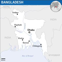
English: Locator map of Bangladesh. |
| Date | |
| Source |
English: Bangladesh Locator Map (ReliefWeb), ESRI, UNCS, Natural Earth |
| Author | |
| SVG genesis |
Nawu wo pfumelela
- You are free:
- to share – to copy, distribute and transmit the work
- to remix – to adapt the work
- Under the following conditions:
- attribution – You must give appropriate credit, provide a link to the license, and indicate if changes were made. You may do so in any reasonable manner, but not in any way that suggests the licensor endorses you or your use.
 This map is part of a collection of 216 free country maps, created by the UN Office for the Coordination of Humanitarian Affairs (OCHA), to be used in print, web or broadcast products.
The ReliefWeb Location Maps released here are maps that highlight a country, its capital, major populated places and the surrounding regions. Attribution Requirements
Using the map without modifications: ensure that the sources and the disclaimer are below the map. Credit as follows: "Credit: OCHA". For use with alteration: remove the OCHA logo and disclaimer following any modification to the map, but keep the data sources as mentioned below the map. Credit the modified map as follows: "Based on OCHA map". You are responsible for the content of your map. We are keen to receive your feedback and hear how you used OCHA's maps. We would be grateful if you would notify us by e-mail and share your work with us. UN Disclaimer
The designations employed and the presentation of material of this map do not imply the expression of any opinion whatsoever on the part of the Secretariat of the United Nations concerning the legal status of any country, territory, city or area or of its authorities or concerning the delimitation of its frontiers or boundaries. |

|
Textual information (e.g. timestamp) once visible in the image itself has been moved into the image metadata and/or image description page. This makes the image easier to reuse and more language-neutral, and makes the text easier to process and search for. Commons discourages placing visible textual information in images. All licenses accepted on Commons permit this type of modification as a derivative work.
If attribution information were removed and the image is not public domain, replace this tag with {{Attribution metadata from licensed image}}.
|
Matimu ya fayili
thlava eka siku/nkarhi leswaku u vona leswi fayili ayirixiswona hi knarhi walowo
| Siku/Nkarhi | Xifanisonyana | Mpimo | Mutirhisi | Nhlamulo | |
|---|---|---|---|---|---|
| Sweswinyana | 23:36, 25 N'wendzamhala 2022 | | 250 × 250 (581 KB) | Wikijahnn | File uploaded using svgtranslate tool (https://svgtranslate.toolforge.org/). Added translation for ca. |
| 07:11, 9 Sunguti 2016 |  | 250 × 250 (580 KB) | Wereldburger758 | Resized page to drawing. Removal watermark. Validation of image. | |
| 22:29, 13 Nyenyankulu 2014 |  | 254 × 254 (573 KB) | UN OCHA maps bot | == {{int:filedesc}} == {{Information |description={{en|1=Locator Map of Bangladesh. {{OCHA map}}}} |date=2013 |source=[http://reliefweb.int/map/bangladesh/bangladesh-location-map-2013 Bangladesh Locator Map (ReliefWeb)] |author=[[w:Uni... |
Ntsengo wakutirhisiwa ka fiyili leyi
tluka leri rikhekela eka fayili leyi:
Global file usage
The following other wikis use this file:
- Usage on azb.wikipedia.org
- Usage on ca.wikipedia.org
- Usage on de.wikipedia.org
- Usage on en.wikipedia.org
- Usage on gor.wikipedia.org
- Usage on id.wikipedia.org
- Usage on incubator.wikimedia.org
- Usage on mai.wikipedia.org
- Usage on min.wikipedia.org
- Usage on sat.wikipedia.org
- Usage on vi.wikipedia.org
_-_BGD_-_UNOCHA.svg)