
File:Algeria 19 Wilaya locator map-2009.svg

Size of this PNG preview of this SVG file: 508 × 500 pixels. Other resolutions: 244 × 240 pixels | 488 × 480 pixels | 780 × 768 pixels | 1,040 × 1,024 pixels | 2,081 × 2,048 pixels.
kuleha na ku anama hixitalo (Fayili ya SVG, vukulu lebyi ringaneke 508 × 500 hi ti phikisele, vukulu bya fayili: 70 KB)
Nkomiso
| Description | |||
| Date | |||
| Source |
Own work
|
||
| Author | Eric Gaba (Sting - fr:Sting) | ||
| Permission (Reusing this file) |
|
Nawu wo pfumelela
I, the copyright holder of this work, hereby publish it under the following licenses:
This file is licensed under the Creative Commons Attribution-Share Alike 3.0 Unported license.
- You are free:
- to share – to copy, distribute and transmit the work
- to remix – to adapt the work
- Under the following conditions:
- attribution – You must give appropriate credit, provide a link to the license, and indicate if changes were made. You may do so in any reasonable manner, but not in any way that suggests the licensor endorses you or your use.
- share alike – If you remix, transform, or build upon the material, you must distribute your contributions under the same or compatible license as the original.

|
Permission is granted to copy, distribute and/or modify this document under the terms of the GNU Free Documentation License, Version 1.2 or any later version published by the Free Software Foundation; with no Invariant Sections, no Front-Cover Texts, and no Back-Cover Texts. A copy of the license is included in the section entitled GNU Free Documentation License. |
You may select the license of your choice.
Matimu ya fayili
thlava eka siku/nkarhi leswaku u vona leswi fayili ayirixiswona hi knarhi walowo
| Siku/Nkarhi | Xifanisonyana | Mpimo | Mutirhisi | Nhlamulo | |
|---|---|---|---|---|---|
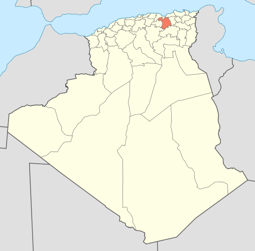
| Sweswinyana | 17:00, 19 Hukuri 2009 | | 508 × 500 (70 KB) | Sting | {{Information |Description={{en|Locator map of the Sétif Province, Algeria, as in 2009.}} {{fr|Carte de localisation de la Wilaya de Sétif, Algérie, telle qu'en 2009.}} | |
Ntsengo wakutirhisiwa ka fiyili leyi
tluka leri rikhekela eka fayili leyi:
Global file usage
The following other wikis use this file:
- Usage on be.wikipedia.org
- Usage on ceb.wikipedia.org
- Usage on de.wikipedia.org
- Usage on fa.wikipedia.org
- Usage on ha.wikipedia.org
- Usage on hi.wikipedia.org
- Usage on id.wikipedia.org
- Usage on ig.wikipedia.org
- Usage on ro.wikipedia.org
- Usage on ru.wikipedia.org
- Usage on simple.wikipedia.org
- Usage on sr.wikipedia.org
- Usage on sv.wikipedia.org
- Usage on sw.wikipedia.org
- Usage on uk.wikipedia.org