
File:LocationTogo.png
Xifaniso lexi axikuriseki kuhundza laha.
LocationTogo.png (250 × 115 ku anama na leha hi ti phikisele, Vukulu bya fayili: 7 KB, muxaka waMIME: image/png)
Nkomiso
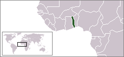
| Description |
English: Location map for the Togo.
Deutsch: Lage von Togo |
| Source | Own work. Originally created for English Wikipedia. |
| Author | Vardion |

|
File:LocationTogo.svg is a vector version of this file. It should be used in place of this PNG file.
File:LocationTogo.png → File:LocationTogo.svg
For more information, see Help:SVG. |
 |
Nawu wo pfumelela
| |
This work has been released into the public domain by its author, Vardion, at the Xi Nghezi Wikipediya project. This applies worldwide. In case this is not legally possible: |
Matimu ya fayili
thlava eka siku/nkarhi leswaku u vona leswi fayili ayirixiswona hi knarhi walowo
| Siku/Nkarhi | Xifanisonyana | Mpimo | Mutirhisi | Nhlamulo | |
|---|---|---|---|---|---|
| Sweswinyana | 22:41, 30 Mhawuri 2011 | | 250 × 115 (7 KB) | Hoshie | added South Sudan |
| 03:36, 13 N'wendzamhala 2004 |  | 250 × 115 (6 KB) | EugeneZelenko | Location map for the Togo.<br/>Originally created for English Wikipedia by Vardion.<br/>{{PD}}<br/>Category:Country locator maps |
Ntsengo wakutirhisiwa ka fiyili leyi
tluka leri rikhekela eka fayili leyi:
Global file usage
The following other wikis use this file:
- Usage on ace.wikipedia.org
- Usage on ar.wikipedia.org
- Usage on be.wikipedia.org
- Usage on bg.wikipedia.org
- Usage on bpy.wikipedia.org
- Usage on bs.wikipedia.org
- Usage on de.wikinews.org
- Usage on de.wikivoyage.org
- Usage on de.wiktionary.org
- Usage on el.wiktionary.org
- Usage on en.wikipedia.org
- Usage on en.wikinews.org
- Violence, allegations of fraud disrupt election in Togo
- Violent rioting, deaths follow disputed election in Togo
- Wikinews:Template messages/Infoboxes/Countries
- Template:Togo
- Togo unanimously vote to abolish the death penalty
- Togo footballers ambushed in Angola
- Two candidates in Togo elections claim victory; votes counted
- Usage on en.wikivoyage.org
- Usage on en.wiktionary.org
- Usage on eo.wikipedia.org
- Usage on es.wikipedia.org
- Usage on es.wikinews.org
- Usage on eu.wikipedia.org
- Usage on frp.wikipedia.org
- Usage on fr.wikipedia.org
- Usage on fr.wiktionary.org
- Usage on he.wikipedia.org
- Usage on he.wikivoyage.org
- Usage on hif.wikipedia.org
- Usage on hi.wikipedia.org
View more global usage of this file.